Appearance
Clean windows, cared-for façades, legible signs and planting that survives the season. Public spaces should feel considered from one block to the next.
PLACE IDENTITY · A COMMUNITY PROPOSAL
A good town gives people reasons to arrive, stay awhile and come back. Roseburg can strengthen that experience through its streets, buildings, public spaces and everyday care—and make a clearer case for the families, businesses and investment it wants to attract.
REAL LOCATION · ILLUSTRATIVE CHANGES
Jackson Street in the Roseburg Downtown Historic District, Roseburg, Oregon
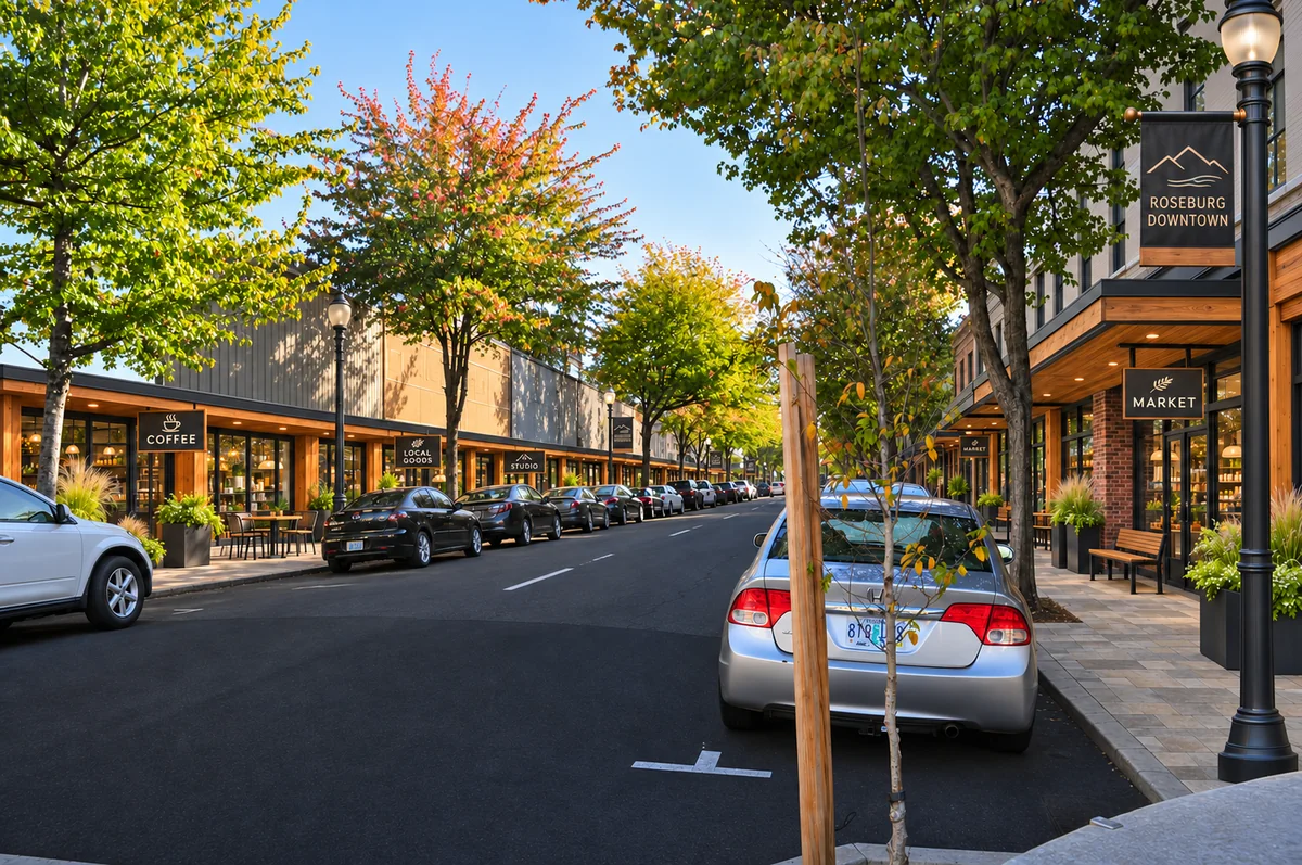
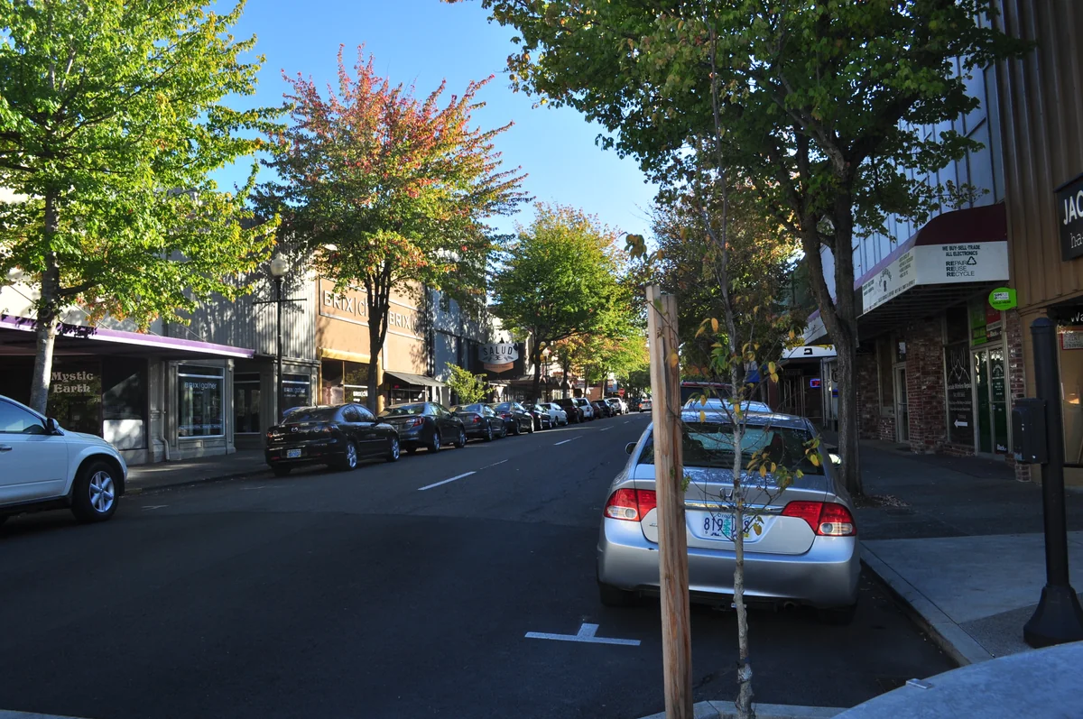
Drag across the image, use the slider or choose a view. Arrow keys also work on the slider. Before: September 2016 photograph. After: an illustrative proposal, not completed work or an approved design.
Original photograph by Joe Mabel · Concept adapted by Greater Roseburg Tomorrow · CC BY-SA 4.0.
“Roseburg, Oregon - Jackson St. 01.jpg” by Joe Mabel, photographed September 28, 2016, CC BY-SA 4.0. View the source photograph
Concept edit by Greater Roseburg Tomorrow, based on a photograph by Joe Mabel. AI-assisted modifications. Licensed CC BY-SA 4.0. AI-assisted complete streetscape concept replacing legacy storefront signs, mismatched awnings and the obsolete white appliance/recycling marquee and burgundy surround with coordinated timber storefronts, charcoal steel canopies, warm neutral facade finishes and generic shop labels. The proposal adds matching benches, planting, civic banners and pedestrian paving. A targeted correction restored the original upper-facade and roofline arrangement after the first generation. The street, trees, vehicles and building forms remain visual references, not measured geometry. Website copies are resized and encoded as WebP.
Read the CC BY-SA 4.0 license . Credit the photographer and Greater Roseburg Tomorrow, link the source and license, and identify modifications when reusing the adapted image. The photographer does not endorse this proposal.
THE DIRECTION TO TEST
That should describe a normal afternoon here: a few useful stops, a meal, something for the kids and a comfortable walk between them.
The ambition is a place that works well for people who already live in the region, with an experience that gives visitors and prospective employers a reason to look again.
What would bring you back?WHAT TOWN BRANDING ACTUALLY INVOLVES
A name, a logo and a campaign can help people recognize a town. Their experience when they get there determines whether the message holds up.
Clean windows, cared-for façades, legible signs and planting that survives the season. Public spaces should feel considered from one block to the next.
A clear route from parking or transit to a shop, a comfortable crossing, somewhere to sit, and enough open places to make the trip worthwhile.
The Umpqua, the hills, historic buildings, public art, independent businesses and local makers. These give the place a character people can recognize and remember.
Someone responsible for watering, repairs, litter, lighting and worn signs. A beautiful opening day means little if nobody has agreed to maintain the work.
BUILD ON WHAT IS ALREADY HERE
Experience Roseburg promotes the area and maintains a downtown mural tour. Its mural project credits the City, property owners and the Historic Resource Review Commission for helping make the work possible. A useful identity effort would connect with that work and the businesses, artists and volunteers already investing in the town.
Two additions were completed on June 22, 2025: Notice Beauty, by Katie Daisy and Karen Eland at 506 SE Jackson Street, and The Watcher, by Brooks Engel at 808 SE Lane Avenue. These completed projects provide a starting point for a better connected downtown.
TWO REAL LOCATIONS · A COMPLETE DESIGN DIRECTION
The proposed designs carry timber, charcoal steel and warm stone tones through storefronts, canopies, signs, seating and planting. Compare the September 2016 photographs with a coordinated vision for the whole street, then choose View full after to inspect each proposal.
REAL LOCATION · ILLUSTRATIVE CHANGES
Jackson Street in the Roseburg Downtown Historic District, Roseburg, Oregon
Drag across the image, use the slider or choose a view. Arrow keys also work on the slider. Before: September 2016 photograph. After: an illustrative proposal, not completed work or an approved design.
Timber entries, charcoal frames and coordinated canopies carry the material palette along the block. Clean sign panels replace the old assemblies, while benches, planting and café seating make the sidewalk more inviting. Individual buildings keep their proportions and architectural details within a shared design direction.
Review each façade with its owner and the relevant historic reviewers. Confirm suitable finishes, clear walking routes, tree protection and delivery access. Proposed shop labels illustrate possible uses; they do not identify participating tenants.
“Roseburg, Oregon - Jackson St. 01.jpg” by Joe Mabel, photographed September 28, 2016, CC BY-SA 4.0. View the source photograph
Concept edit by Greater Roseburg Tomorrow, based on a photograph by Joe Mabel. AI-assisted modifications. Licensed CC BY-SA 4.0. AI-assisted complete streetscape concept replacing legacy storefront signs, mismatched awnings and the obsolete white appliance/recycling marquee and burgundy surround with coordinated timber storefronts, charcoal steel canopies, warm neutral facade finishes and generic shop labels. The proposal adds matching benches, planting, civic banners and pedestrian paving. A targeted correction restored the original upper-facade and roofline arrangement after the first generation. The street, trees, vehicles and building forms remain visual references, not measured geometry. Website copies are resized and encoded as WebP.
Read the CC BY-SA 4.0 license . Credit the photographer and Greater Roseburg Tomorrow, link the source and license, and identify modifications when reusing the adapted image. The photographer does not endorse this proposal.
REAL LOCATION · ILLUSTRATIVE CHANGES
Former Booth/Douglas National Bank building, 567 Southeast Jackson Street, Roseburg, Oregon
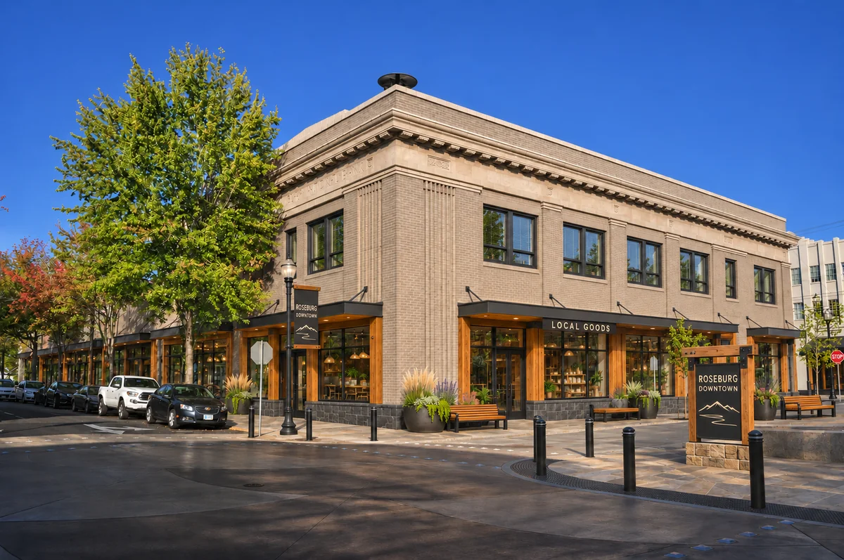
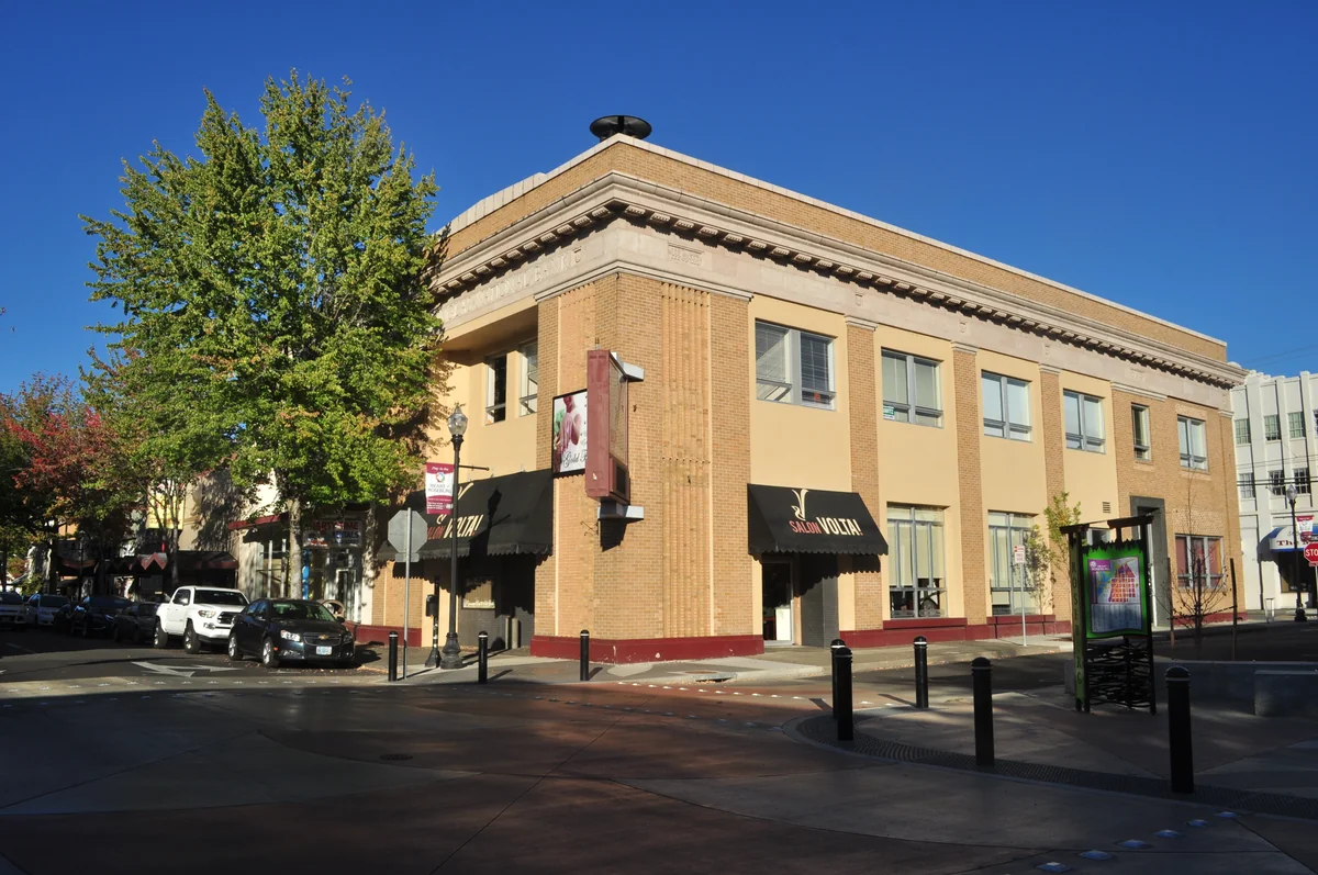
Drag across the image, use the slider or choose a view. Arrow keys also work on the slider. Before: September 2016 photograph. After: an illustrative proposal, not completed work or an approved design.
The proposal brings the façade, storefront frames, canopies and sign structure into the same timber, charcoal and warm stone palette. Substantial benches and planted edges complete the public space. The building’s roofline, cornice and upper-window rhythm remain recognizable.
Assess historic materials, storefront openings and structural feasibility before specifying the façade work. Confirm ownership, maintenance access, clear routes and crossing sightlines. Sign content, directions and fixture positions need an on-site review.
“Roseburg, Oregon - former Douglas National Bank.jpg” by Joe Mabel, photographed September 28, 2016, CC BY-SA 4.0. View the source photograph
Concept edit by Greater Roseburg Tomorrow, based on a photograph by Joe Mabel. AI-assisted modifications. Licensed CC BY-SA 4.0. AI-assisted complete facade and public-space concept with warm greige textured masonry, charcoal upper window frames and a dark stone base, timber storefront surrounds, more open retail glazing, and flat steel canopies with timber soffits. The old salon lettering, scalloped awnings, projecting brown blade and burgundy base are removed. Generic LOCAL GOODS signage, a timber-and-steel civic kiosk, benches and planting complete the proposal. A targeted correction restored the far-right STOP sign. The historic silhouette and street arrangement remain visual references, not measured geometry. Website copies are resized and encoded as WebP.
Read the CC BY-SA 4.0 license . Credit the photographer and Greater Roseburg Tomorrow, link the source and license, and identify modifications when reusing the adapted image. The photographer does not endorse this proposal.
The before photographs show signage recorded in 2016. Shop labels, destination names and arrows in the proposed designs are illustrative; no tenant participation or verified route is implied. Read all image credits and reuse terms
ELEVEN MORE PLACES TO REIMAGINE
Follow the same design direction through Stephens, Harvard, Garden Valley and the wider region. Compare street renewal, proposed development locations and the care of existing neighborhoods.
Three ways to read the vision. Street photographs become illustrative renewal concepts. Aerial views show where proposed uses and connections would fit. The rural pair demonstrates repairs on a fictional property. Each view explains its evidence and the decision needed next.
How separate developers can deliver one coherent planShowing Stephens / OR 99 gateway, comparison 1 of 11.
STEPHENS AT WASHINGTON · CORRIDOR RENEWAL
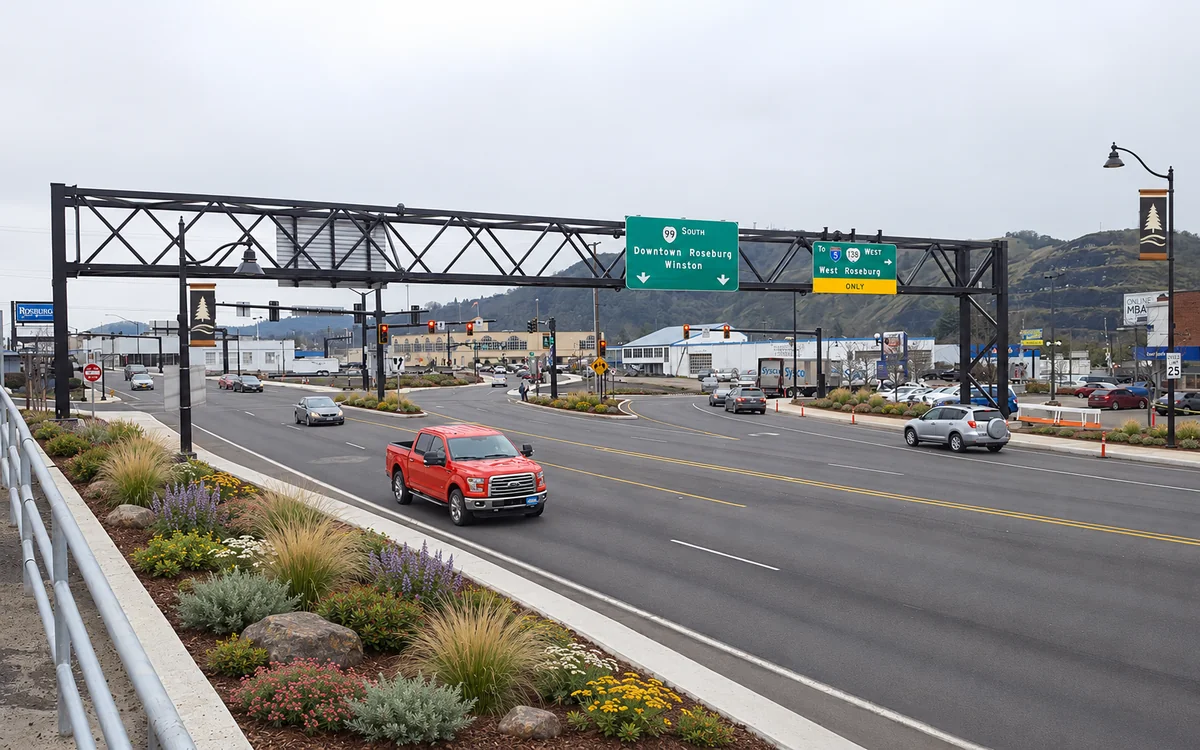
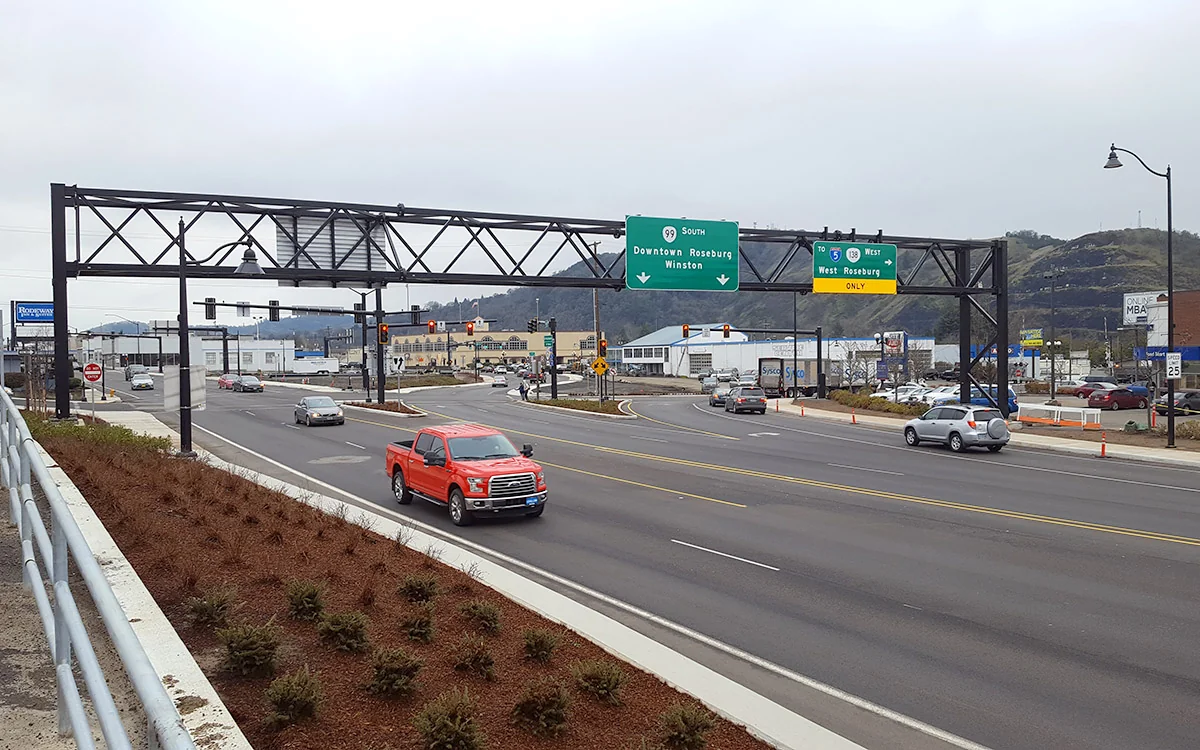
January 2017 photograph; conditions may have changed. The AI-assisted after shows a design direction, not completed work or an engineering plan. Use the buttons, drag across the image or use arrow keys on the slider.
A cared-for entrance sets the tone for the rest of town. This proposal renews existing planted beds and introduces coordinated civic banners while retaining the photographed roads, buildings and access.
Original photograph by the Oregon Department of Transportation. The roadway realignment visible in the reference was already completed by ODOT; it is not a GRT project. The after image is an AI-assisted adaptation by Greater Roseburg Tomorrow limited to planting and civic banners. It does not propose new buildings or road closures. Current conditions, permissions and engineering details still require review.
ODOT · Stephens Street photograph · January 1, 2017 · CC BY 2.0.
One regional plan. Separate, workable projects. These views identify roles and connections; they do not allocate someone’s property or promise several competing regional malls. Match each opportunity to demand, legal use, access and capacity, then agree who builds and maintains the shared pieces.
Explore sites on the regional mapA SHARED VISUAL LANGUAGE
Carry a small family of materials through the whole project: building fronts, canopies, signs, furniture and paving. Warm timber, charcoal steel, stone tones and planting give the street a welcoming character that people can recognize from one block to the next.
WORKING DESIGN SAMPLES · NOT AN OFFICIAL IDENTITY
Proposed material and lettering direction. Greenery and seasonal planting supply the color. This is an illustrative sample, not an adopted city identity or an approved sign.
Consider the façade, window frames, entrance, canopy and signs together. Remove obsolete sign panels and fittings as part of the work. Agree a coordinated palette with participating owners, then carry it through each visible frontage and the public space beside it.
Use visible timber grain, simple charcoal steel frames and warm stone tones, with bronze reserved for small details. Keep lettering readable and allow planting to provide seasonal color. Check directions and walking routes before adding them to signs.
Retain the proportions, cornices, window rhythms and details that give each building its character. Review historic masonry before choosing cleaning, repairs or any finish treatment. Businesses can express their own identity through well-designed signs within the shared material palette.
Choose replaceable bench slats, serviceable fixtures and finishes that the responsible team can maintain. Review material samples, weather exposure, cleaning and replacement costs before ordering. Each installation needs a named person or organization responsible for its care.
Provide resting opportunities without narrowing the clear walking path. Review placement with people who will use them.
Choose appropriate species, irrigation and replacement responsibility before installing a planter or basket.
Have lighting checked for useful illumination, glare, neighboring properties, energy use and maintenance access.
A PRACTICAL FIRST STEP
Investigate a short Jackson–Main downtown route with willing owners and the City. Link destinations that already draw people, then improve the experience between them before attempting a citywide rollout.
Choose the final blocks after walking them and talking with owners. The route should connect real destinations, practical parking and transit connections, and a comfortable place to pause. Review crossings and visibility as part of that work.
Coordinate with existing businesses and events. Test a few dependable evening openings with willing operators, so someone arriving after work has a reason to stay. Keep the link to parks and trails in the wider plan, without implying that an unreviewed route is accessible or complete.
DAYS 1–30
Bring willing Jackson and Main Street owners, merchants, City staff and residents together for a daytime and evening walk. Include people using wheelchairs, mobility aids and strollers. Choose one manageable route between existing destinations and make a dated record of what works and what gets in the way.
DAYS 31–60
Test sign sizes and locations on site. Have the responsible staff and professionals review clear walking space, crossings, curb ramps, visibility, deliveries and emergency access. Obtain permissions, historic review where applicable, quotes and a funded maintenance agreement.
DAYS 61–90
Install only the work that has permission and funding. Pair the route with an existing event or a voluntary evening-opening trial, then observe ordinary days as well. Record obstacles, make small corrections and publish what was learned before proposing a larger rollout.
MAKE THE WORK LAST
An identity effort needs a working agreement. Each participant should know what they can decide, what they are paying for and what they will maintain after the first event.
MEASURE THE EXPERIENCE
Record a baseline before installation. Repeat observations at the same locations and comparable times, noting weather, events and other changes that could affect results.
Publish the method and the limits alongside results. A busier event day does not establish lasting growth, and a refreshed street image does not prove a financial return. Use the evidence to decide what deserves another investment.
FOR DEVELOPERS AND BUSINESS OWNERS
A clear design direction, maintained public spaces and a dependable process give a prospective operator something concrete to evaluate. Pair that work with current property information, utilities, realistic costs and a capable operator.
HELP SHAPE THE FIRST ROUTE
Tell us about your experience of Roseburg. Which details make you proud of the place? Where does a visit become difficult? What would give you a reason to return more often?
People in Green, Winchester, Sutherlin, Myrtle Creek, Drain, Yoncalla and other surrounding communities use the town too. Their experiences belong in this discussion.
This is voluntary community feedback, not a representative poll or an official City consultation. Responses can point to useful questions; they do not establish a mandate.
Local project sources reviewed November 10, 2026. The proposed identity, route, schedule and responsibilities above are Greater Roseburg Tomorrow discussion proposals. They are not adopted City policy.